
Urban Participation
We explore how people perceive cities and neighborhoods, and how to shape them.
Our research explores how the physical, social, and economic structures of urban environments evolve and how citizens can shape them. Using crowdsourced participation efforts, computer vision, and AI on large-scale urban data we study people’s preferences over urban designs and how to improve them.
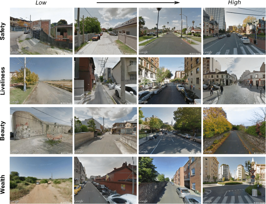
Our work includes iconic projects such as Place Pulse (2011), a global crowdsourcing platform that collected millions of human judgments about the perceived safety, beauty, and liveliness of urban streetscapes. These perceptions were then used to train StreetScore (2014), one of the first large-scale computer vision models for estimating the aesthetic qualities of urban environments from street-level imagery. Building on this, StreetChange (2017) tracked how neighborhoods physically evolve by comparing historical street-level imagery, showing that urban change is more likely explained by the urban quality of neighboring districts and the density of highly educated individuals than by measures of wealth or income.
Together, these projects demonstrate how visual data, machine learning, and network methods can reveal the underlying logic of urban systems. For students and researchers, the Center for Collective Learning offers a unique environment to study cities at the intersection of technology, design, and social science, advancing tools that help us understand urban change and imagine more equitable, vibrant urban futures.
PlacePulse & Streetscore - Mapping Urban Perception
Starting in 2010, our team has been working to understand how people perceive the urban environment and the implication of such perception.
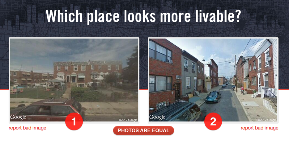
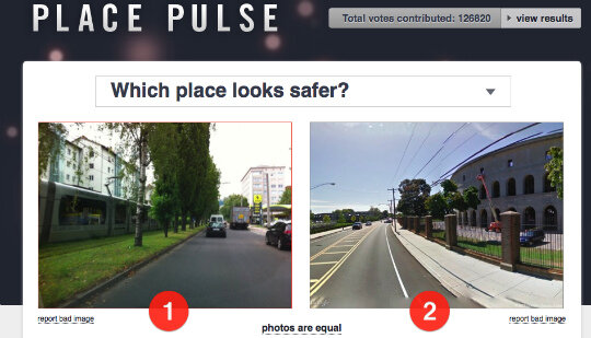
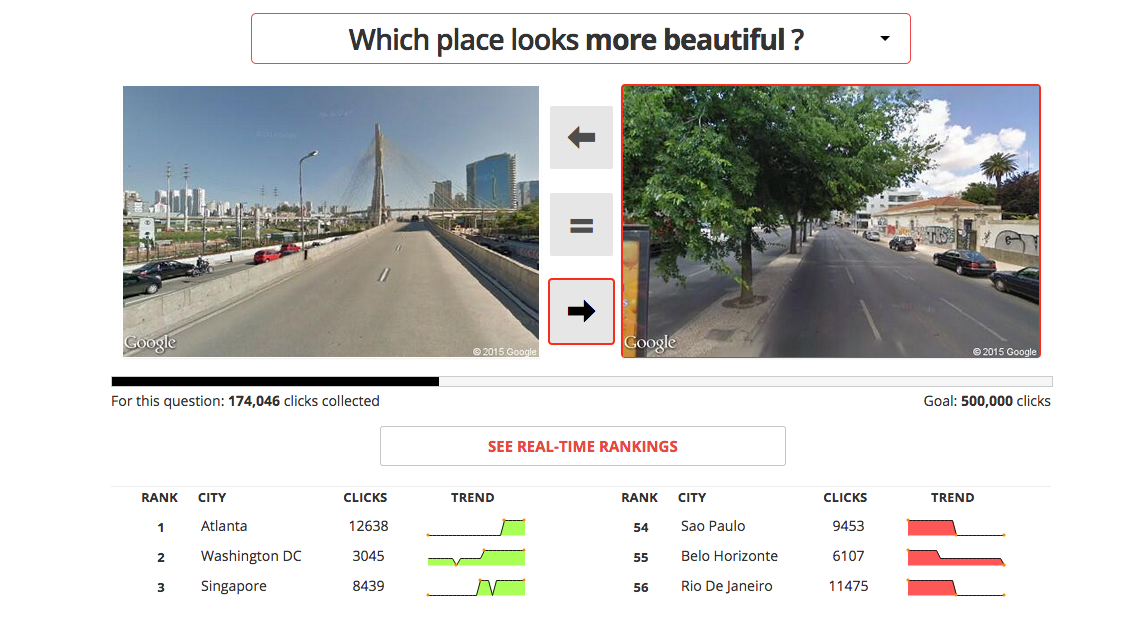
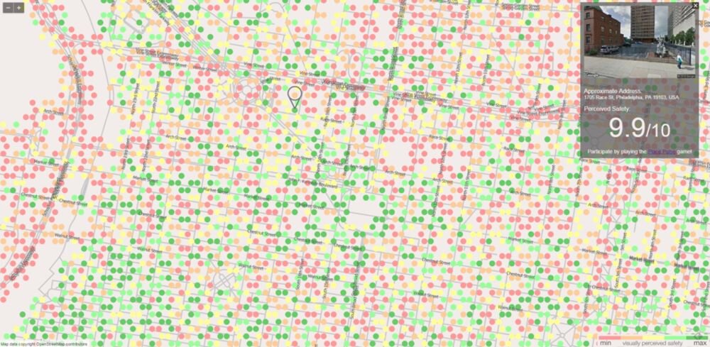
Our work began with the creation of a crowdsourcing platform called “Place Pulse,” that asked people to click on an image from a pair in response to an evaluative question, such as “which place looks safer?” or “livelier?“
This first version of Place Pulse (Place Pulse 1.0), collected more than 500,000 preferences which were used to evaluate about 4,000 images for four cities (Boston, New York, Linz, and Salzburg), and to study the spatial correlation and the inequality of the perceived quality of the urban environments (Link to Paper). A few years later, we created an updated version of the platform (Place Pulse 2.0), with images from more than 50 cities, which collected more than 1 million preferences.
From Crowdsourced Data to Machine Learning Models
We used the data collected in Place Pulse 1.0 and 2.0 to train several machine learning models.
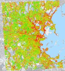
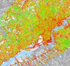
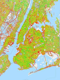
In 2014, we used the Place Pulse 1.0 dataset, together with a support vector machine model, to create a dataset scoring one million streetscapes (Link to Paper).
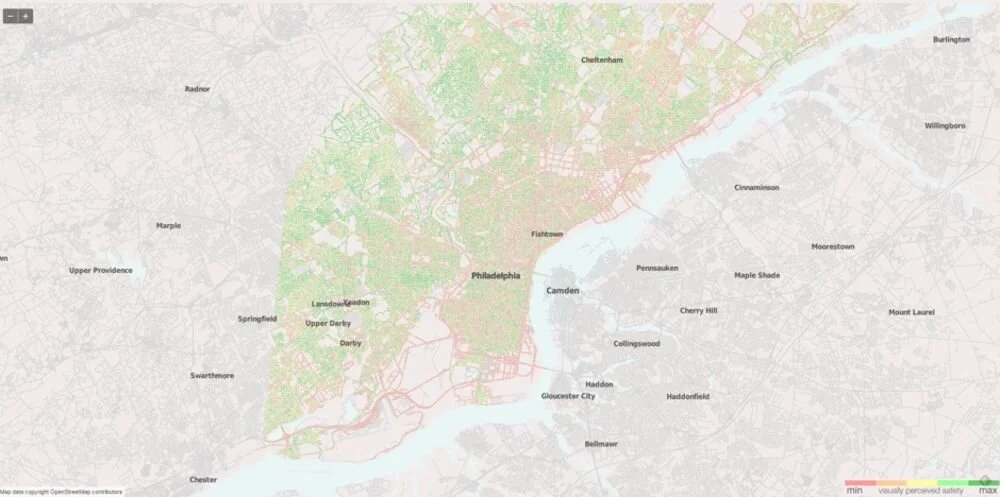
Streetscore allowed us to increase the resolution of urban perception maps by several orders of magnitude. With Place Pulse, we could only create evaluative maps with a neighborhood resolution (e.g. a few thousand images for a city as large as New York). This was problematic, since even in a single street segment, the quality of urban space can exhibit large degrees of variation. The introduction of machine learning methods, such as Streetscore, helped us create maps with street level resolution (hundreds of thousands of images). Soon after releasing Streetscore, we switched our support vector machine methodology for a deep learning model (Link to paper).
Understanding Urban Perception
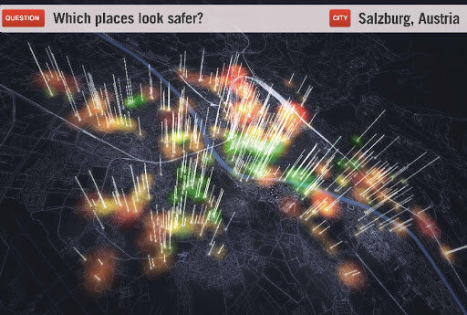
Together, the crowdsourced data and the machine learning models, opened the opportunity to study several aspects of urban perception. In a collaboration with people from the Bruno Kessler Foundation (FBK) we studied the correlation, between the perception of safety, and the activity of neighborhoods (as measured by mobile phone records). We found that safer looking neighborhoods were more active, and that the correlation between the perception of safety and urban activity was larger for women and the elderly.
In another paper, published in PNAS, we used our machine learning models to study physical urban change. We found that neighborhoods densely populated by highly educated people experienced comparatively faster physical urban change. We also found evidence that physical urban change spread geographically, since neighborhoods with low values of streetscore, experienced more positive physical urban change when they bordered neighborhoods with higher streetscore values.
In less than a decade, our contributions went from showing that urban perception could be quantified, to showing the impact of urban perception for urban activity and physical urban change. Today, scholars in various academic communities continue to be inspired by these ideas and methods.
Resources
Code and Datasets
Place Pulse 1.0 dataset
Place Pulse 2.0 dataset (Data)
Place Pulse Open Source Repository (github)
Related Papers
14.-INVESTIGATING PATTERNS OF TOURIST MOVEMENT USING MULTIPLE DATA SOURCES
Margarida Abreu Novais, Bruno Del Papa,Qiwei Han, Kaushik Mohan, Orsolya Vásárhelyi, Yanbing Wang, and Leid Zejnilovic
Journal of Vacation Marketing (2025)
Published Version (PDF)
13.-INTERCITY CONNECTIVITY AND URBAN INNOVATION
Xiaofan Liang, César A. Hidalgo, Pierre-Alexandre Balland, Siqi Zheng, Jianghao Wang
Computers, Environment and Urban Systems (2024)
Published Version (PDF)
12.-TRILLION DOLLAR STREETS
César A. Hidalgo,
Environment and Urban Planning B: Urban Analytics and City Science (2020)
Published Version (PDF)
11.-THE AMENITY MIX OF URBAN NEIGHBORHOODS
César A. Hidalgo, Elisa Castañer, Andres Sevtsuk
Habitat International (2020)
Published Version (PDF)
10.-COMPLEX ECONOMIC ACTIVITIES CONCENTRATE ON LARGE CITIES
Pierre-Alexandre Balland, Cristian Jara-Figueroa, Sergio Petralia, Mathieu Steijn, David Rigby, and César A. Hidalgo.
Nature Human Behavior (2020)
Published Version (PDF)
9.-COMPUTER VISION UNCOVERS PREDICTORS OF PHYSICAL URBAN CHANGE
NIKHIL NAIK, SCOTT KOMINERS, RAMESH RASKAR, EDWARD GLAESER, CESAR A. HIDALGO
Proceedings of the National Academy of Sciences (2017)
Published Version (PDF)
PRESS: Forbes | MIT News | Fast CoDesign | TechXplore
8. ARE SAFER LOOKING NEIGHBORHOODS MORE LIVELY? A MULTIMODAL INVESTIGATION INTO URBAN LIFE
MARCO DE NADAI, RADU LAURENTIU VIERIU, GLORIA ZEN, STEFAN DRAGICEVIC, NIKHIL NAIK, MICHELLE CARAVIELLE, CÉSAR A. HIDALGO, NICU SEBE, BRUNO LEPRI
Proceedings of the 2016 ACM on Multimedia Conference 1127-1135 (2016)
Published Version (PDF)
PRESS: MIT NEWS | FAST COMPANY
7. DEEP LEARNING THE CITY: QUANTIFYING PERCEPTION AT A GLOBAL SCALE
ABHIMANYU DUBEY, NIKHIL NAIK, DEVI PARAH, RAMESH RASKAR, CÉSAR A. HIDALGO
European Conference on Computer Vision, 196-212 (2016)
Published Version (PDF)
6. CITIES ARE PHYSICAL TOO: USING COMPUTER VISION TO MEASURE THE QUALITY AND IMPACT OF URBAN APPEARANCE
NIKHIL NAIK, RAMESH RASKAR, AND CÉSAR A. HIDALGO
The American Economic Review 106 (5), 128-132 (2016)
Published Version (PDF)
5. STREETSCORE--PREDICTING THE PERCEIVED SAFETY OF ONE MILLION STREETSCAPES
NIKHIL NAIK, JADE PHILIPOOM, RAMESH RASKAR, AND CÉSAR A. HIDALGO
CVPR Workshop on Web-scale Vision and Social Media (2014)
Published Version (PDF)
PRESS: The Economist | Fast Company | Daily Mail | New Scientist | Gigazine | Gothamist
4.- THE COLLABORATIVE IMAGE OF THE CITY: MAPPING THE INEQUALITY OF URBAN PERCEPTION
PHILIP SALESSES, KATJA SCHECHTNER, AND CÉSAR A. HIDALGO
PLoS ONE 8(7): e68400. DOI: 10.1371/journal.pone.0068400
Published Version (PDF)
PRESS: Wired UK | Ars Technica | Slate.fr | Studio-X NYC Blog | T3 | Gigazine | La Nación
Phys.org | MIT News | The Atlantic | Slashdot | Wired Japan | Catraca Livre | Derstandard | FastCoExist | The Gothamist
3. UNIQUE IN THE CROWD: THE PRIVACY BOUNDS OF HUMAN MOBILITY
YVES-ALEXANDRE de MONTOJOYE, CÉSAR A. HIDALGO, MICHEL VERLEYSEN, AND VINCENT D. BLONDEL
Scientific Reports DOI 10.1038/srep01376 (2013)
Published Version (PDF)
PRESS: MIT News | MIT Technology Review | CNN | BBC | Wired UK | Huffington Post UK | Fast Company | TechMeme | Phys.org | The Register | UPI.com | GigaOM | The Telegraph | Popular Science | La Stampa | Developpez.com | der Standard | The Times of India | The Independent | De Telegraaf | Live Science
2. UNDERSTANDING THE SPREADING PATTERNS OF MOBILE PHONE VIRUSES
PU WANG, MARTA C. GONZALEZ, CÉSAR A. HIDALGO, ALBERT-LÁSZLÓ BARABÁSI
Science (2009) 324:1071-1076
Published Version (PDF)
PRESS: Scientific American | Tucuman Hoy | Diarionco | Academiadeciencias.com | Perspectiva Sur | BBC | PhysOrg | FSecure | Red Orbit | LeMagIT | Washington Post | Science | ND NewsWire | Galileo | CBC | IT Pro | ars technica | Scientific American | Newswise | Stuttgarter Zeitung | US News
1. UNDERSTANDING INDIVIDUAL HUMAN MOBILITY PATTERNS
MARTA C GONZALEZ, CÉSAR A. HIDALGO, ALBERT-LÁSZLÓ BARABÁSI
Nature (2008) 453: 779-782
Published Version (PDF)
PRESS: The New York Times | Nature | BBC | La Republica | Voice of America | CBC | NZ Herald | Chosun | Health MSN | PBS | ABC | Live Mint | AFP | Science Now | Newswise | News.scotman.com | ABC News | Reuters